

Introduction
Does your construction progress reporting rest on facts or assumptions? Reality capture will get rid of assumptions.
In many construction sites, progress reports are still generated using assumptions of the subcontractor, pictures from past times, and informal discussions held in the hallways. The subcontractor will say that the job is 80% complete, whereas the general contractor says that it is 60% done. What the owner needs is concrete proof, not an assumption.
Reality Capture takes care of this issue right from the source. With the help of drones, LiDAR, and 360-degree cameras, it helps transform the job site into a measurable and time-stamped piece of data rather than an issue that needs to be discussed. This blog will explain what reality capture entails, how it functions using different capture technologies, and how to implement reality capture at scale to measure construction progress.
What Is Reality Capture in Construction?
Reality capture in the context of construction refers to the digital recording of a physical jobsite for measurements, comparisons, and data exchange. In contrast to just having a file of photographs, reality capture delivers a well-structured visual documentation of the jobsite as it exists.
This is not an individual tool; reality capture technology refers to a set of technologies that consist of the use of drones, laser scanning, 360-degree cameras, and even smartphone devices used by software capable of creating useful outputs out of the raw data obtained through these devices. The key feature that distinguishes reality capture from regular site photography is that the output is measurable.
How Reality Capture Turns a Job Site into Data
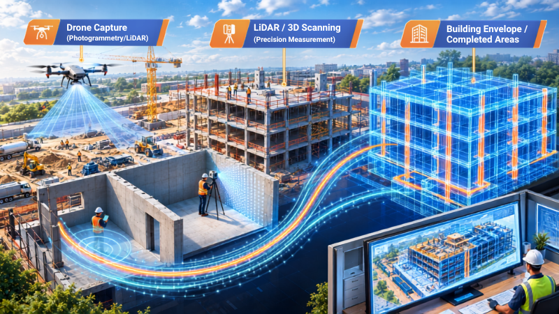
At a basic level, reality capture in construction works in three steps:
- Capture: A drone, laser scanner, or 360° camera collects images or scan data from the site
- Process: Software stitches that raw data into a usable format, such as a 3D model, a map, or a walkthrough.
- Compare: The output is measured against the design, the schedule, or an earlier capture to show what has changed.
This is where the real value lies in the process. One single capture is just an instant photo. But multiple captures taken at regular intervals will serve as a chronology of the project.
Point Clouds, Meshes, and Digital Twins, Explained
Reality capture produces a few common types of output, and it helps to know the difference:
- Point cloud: A collection of millions of individual data points in 3D space, generated by LiDAR scanning or photogrammetry. A point cloud construction dataset is the raw material behind the most accurate measurements and comparisons.
- 3D Mesh: This is a point cloud with surfaces incorporated, thus giving it the characteristics of an object.
- Orthomosaic: This is a flat map taken from an aerial view that has been rectified and is capable of measurement.
- Digital twin: A living and evolving model in 3D or 360 degrees of the site or asset. The digital twin construction model is not a single snapshot in time. It evolves according to a defined schedule such that it always represents the current state, not just the moment it was created.
Knowing what the outputs are important because you want to ensure that the right tool is used for the particular output. A weekly update will need a different level of accuracy than an as-built survey.
Drones, LiDAR, and 360° Cameras: The Three Pillars of Reality Capture at Scale
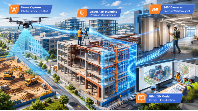
One instrument cannot perform each task on-site. Scalable reality capture involves the combination of equipment, depending on the nature of work required, its speed and accuracy.
Drones for Aerial Construction Mapping and Site Surveys
Drones are the preferred equipment used for expansive projects, outdoors spaces, and inaccessible locations. A survey of the construction site using a drone can cover a vast area in one go, which would take the ground team days to walk through and survey.
Drones typically carry one of two sensor types:
- Photogrammetry drones take overlapping photographs, which are processed by the software to create 3D models and orthomosaics. This method is relatively cheaper and suitable for aerial construction mapping and site layout monitoring.
- LiDAR-equipped drones, which is equipped with laser pulses rather than photos. It is well-suited for places where vegetation or complicated geography is present or projects requiring high precision in measurement.
Since drone construction progress tracking takes an aerial view of the entire project site, it becomes particularly helpful in earthworks, grading, roofing, or any other exterior project milestones, which require bird’s-eye photos.
LiDAR and 3D Laser Scanning for Millimeter-Level Accuracy
When a project needs precision measured in millimetres rather than centimetres LiDAR scanning construction is the standard. LiDAR works by firing laser pulses at a surface and measuring how long they take to bounce back, building a dense point cloud from the results.
3D laser scanning construction is commonly used for:
- Pre-construction surveys of existing conditions
- Structural steel and MEP rough-in verification, where clashes are expensive to fix later
- As-built documentation that needs to hold up for engineering or legal review
The downside is time and price. Laser scanning is more time consuming and costly than using a drone and doing a 360° walkaround; laser scanning is normally used in cases when precision is more important than speed.
360° Cameras for Fast, Frequent Interior Documentation
The 360-degree camera provides the quickest and most cost-effective means of capturing interior images. Just one individual is required to do a walk-through of a floor using a 360-degree camera, capturing all images at an incredible speed compared to using laser scanning.
360-photo construction documentation is becoming very common as it reduces the cost of capture. One is able to have weekly or even daily walks through without breaking the bank because the technology is that easy to use. However, there will be a loss in accuracy since 360-degree capture is just visual.
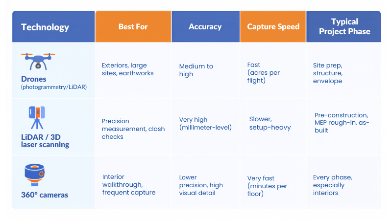
Most reality capture programs do not pick one technology. They layer all three, using drones outside, LiDAR where precision matters most, and 360° cameras for fast, routine interior coverage.
How Reality Capture Powers Construction Progress Tracking
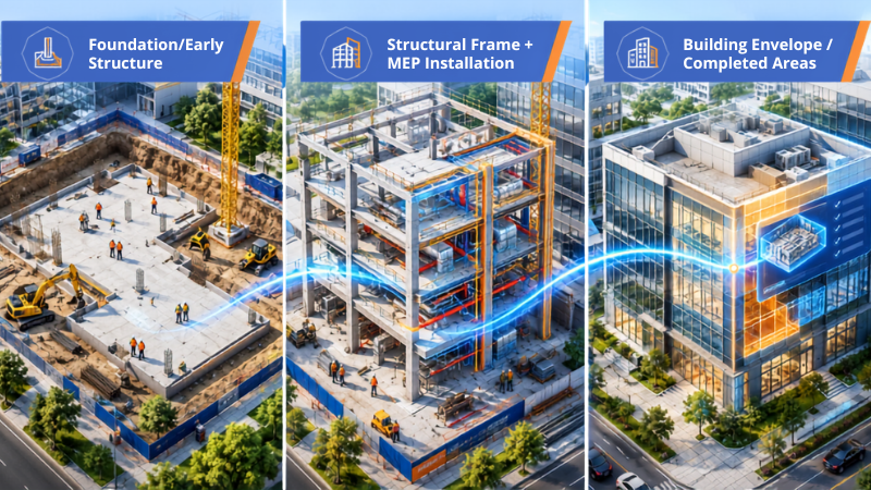
That is when reality capture pays off. There has never been any doubt that construction progress reporting was all about field visits, photos and meetings. Reality capture eliminates the guessing game by bringing the visual and measurable proof.
From Site Walk to Weekly Progress Reports
A typical construction progress tracking workflow looks like this:
- A field team captures the site using a drone, 360° camera, or scanner, on a set schedule.
- Construction progress monitoring software processes the capture and aligns it to the site's floor plan or coordinates.
- Project managers, owners, and consultants review the update remotely, without a site visit.
- The capture is logged as part of a running project timeline, so any stage can be reviewed later.
Because every capture is timestamped and located, disputes over “what was actually done, and when” become much easier to resolve. Instead of arguing from memory, teams can pull up the record.
Comparing As-Built Conditions to BIM
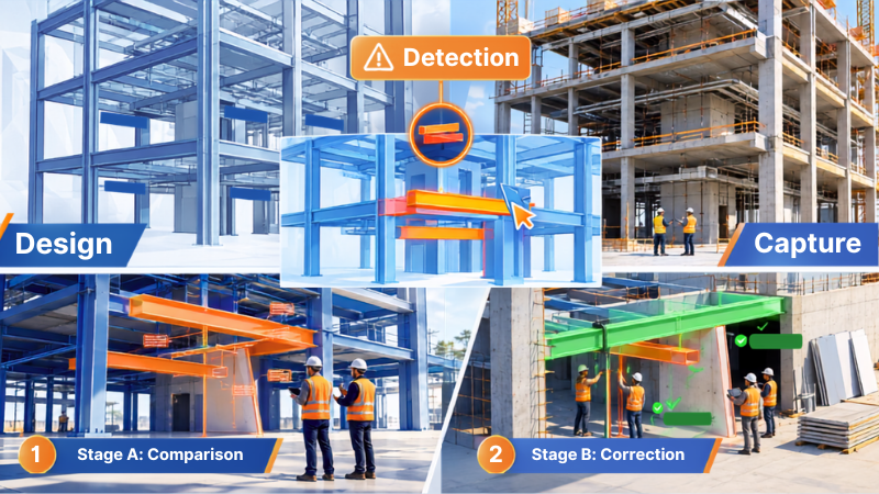
Among those working with Building Information Modeling, one of the most valuable uses of the technology comes through BIM reality capture. With the comparison of the point cloud or the 3D capture with the BIM model, teams will have an idea on where site conditions are different from the design.
This is crucial as rework due to conflicting information is well known and costly. According to the study made by FMI and PlanGrid, non-optimal activities like rework and looking for project data resulted in a loss of 177.5 billion dollars’ worth of labor in the U.S. construction industry within a year, and that almost half of rework is due to poor communication and wrong information (Autodesk / FMI research).
Catching Deviations Before They Become Rework
It’s much less costly the sooner an error is discovered. As reported by the Construction Industry Institute, rework on-site costs approximately 5 percent of total project cost on average, and a reported range is from 2 percent to 20 percent of total project cost, based upon the project (ASCE Civil Engineering Source). This is quite a variance for a mid-sized project.
Regular reality capture, compared against plans or a prior capture, surfaces these issues while a wall is still open, before cladding goes up, or before a slab is poured. That is the difference between a quick correction and a change order.
Beyond Progress Photos: High-Value Reality Capture Use Cases
It’s the most obvious use case for progress tracking, but it’s far from being the only one. After you implement a reality capture solution, that data enables a number of other workflows too.
Earthwork and Material Volume Calculations
Reality capture using drones is commonly employed in earthwork volume calculation. The use of a drone to survey the construction site enables one to calculate the volume of the stockpiles, cut/fill volumes, and grading very quickly compared to manual survey methods, which is significant when dealing with payment and scheduling.
Quality Control and Clash Detection
When point clouds are compared to the design models, conflicts and tolerance violations appear as quantitative discrepancies and not subjective views. The most common quality assessments are:
- Verifying that structural elements match design dimensions
- Confirming MEP rough-in locations before walls close
- Checking envelope alignment before cladding or facade work begins
Catching these issues through reality capture, rather than during a walkthrough months later, keeps small errors from becoming expensive ones.
As-Built Documentation for Facility Handover
In project close-out, the as-built model produced using reality capture serves as permanent documentation for the owner. This means that the owner is presented not with drawings that are full of revisions but with a searchable and measurable 3D representation of what has been constructed.
A Practical Reality Capture Workflow for Large Projects
Scaling reality capture requires more than purchasing equipment.
The process needs to be repeatable.
Step 1: Define the Purpose
Start with the question:
What decision will this data support?
Possible objectives include:
- Progress tracking
- Quality control
- As-built documentation
- Existing-condition surveys
- Design coordination
- Earthwork analysis
- Remote collaboration
- Handover documentation
The objective should determine the capture method.
Step 2: Select the Right Technology
There is no single technology that works best for every project.
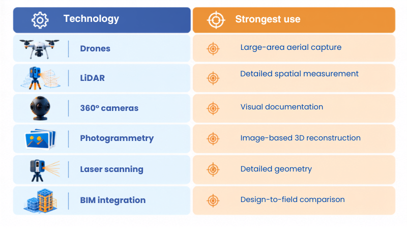
Research in construction similarly indicates that technology selection should depend on the type of data required, as well as factors such as cost, speed, data value, and training needs.
Step 3: Establish a Consistent Capture Schedule
Capturing the initial data forms a baseline.
Capturing data once provides a snapshot
Capturing it repeatedly creates a timeline.
The frequency should match the project’s pace.
For example:
- Weekly for general progress
- More frequently during high-activity phases
- Milestone-based for specific deliverables
- Targeted capture for high-risk areas
Step 4: Keep Capture Routes Consistent
Consistency makes comparisons easier.
For each capture cycle, establish:
- Similar routes
- Similar viewpoints
- Consistent naming
- Consistent coordinate references
- Defined areas of coverage
- Clear file organization
This becomes especially important when multiple teams are collecting data across a large project.
Step 5: Process, Analyse and Organize the Data
Raw data is not automatically useful information.
Teams may need to:
- Register scans
- Align datasets
- Remove unnecessary data
- Generate point clouds
- Create models
- Organize imagery
- Connect captures to project locations
- Prepare BIM or CAD-compatible outputs
A clear data structure becomes increasingly important as capture frequency increases.
Step 6: Compare and Act
The final step is where reality capture becomes valuable.
Don’t stop at:
“Here is the latest scan.”
Ask:
“What changed?”
Then determine:
- Is progress on schedule?
- Is installed work consistent with design intent?
- Are there potential coordination issues?
- Is additional inspection required?
- Does the project team need to act?
This is the difference between collecting site data and using site data for project decisions.
Common Challenges When Scaling Reality Capture
Reality capture can improve project visibility, but it is not automatically simple.
- Too Much Data : More capture can produce more files, images, scans, and models. Without a clear data-management process, teams can struggle to find what they need.
- Inconsistent Capture : If every capture is performed differently, comparing progress becomes harder. Standard routes and schedules can help
- Choosing the Wrong Technology: A high-precision scanner may be unnecessary for a basic visual progress record. Likewise, standard photographs may not be enough when dimensional verification is required.
- Data Quality Problems : Lighting, weather, dust, reflective surfaces, occlusion, movement, and incomplete coverage can affect results depending on the technology being used.
- Regulatory and Site Constraints: Drone operations can be subject to local aviation rules and site-specific restrictions. Weather and safety conditions can also affect aerial capture.
7 Proven Ways to Make Reality Capture More Useful
- Capture With a Specific Purpose :Do not collect data simply because technology makes it possible. Define the intended use first.
- Capture Early: An initial record of existing conditions gives the team a useful baseline.
- Capture Consistently : Repeatable routes, schedules, and naming conventions make comparison easier.
- Combine Technologies When Needed: Drones, LiDAR, 360° imaging, and photogrammetry serve different purposes. The strongest workflow may use more than one.
- Connect Capture to BIM: Site data becomes more valuable when it can be compared with project information.
- Focus on High-Risk Areas :Not every part of a project needs the same capture frequency. Prioritize areas where changes, coordination issues, or schedule risks are more likely.
- Turn Data into Decisions :The final objective should not be another folder of photographs or scans. It should be better project visibility and better decisions.
Need Better AEC Project Support?
Reality capture can provide valuable project data, but turning that data into better design, coordination, and project decisions requires the right technical approach.
Contragenix AEC Design & Support helps AEC teams with Architectural design, BIM, infrastructure, engineering and technical support tailored to project requirements.
Conclusion
Reality capture has moved beyond a specialized process that was available only to big projects. The integration of drones, LiDAR technology, and 360-degree cameras provide a precise, timestamped, and measurable documentation of the actual status on ground for all sizes of projects. Reality capture, used as a consistent process, transforms construction progress monitoring into a proven practice, identifies deviations to prevent rework, and provides the owners with an as-built documentation that continues to provide value long after the handover.
The technology is not important; it is the discipline that counts. Select the best capturing process per stage, maintain a regular rhythm and integrate the data into the BIM process and construction project management, and reality capture will become one of the highest return processes for construction teams.
Scale Your AEC Projects with Expert Design Support
Whether you’re managing multiple projects or facing resource constraints, our experienced engineering professionals seamlessly integrate with your team to provide accurate design, drafting, BIM coordination, and technical documentation, keeping your projects on schedule and within budget.